|
|

楼主 |
发表于 23-11-2007 05:54 PM
|
显示全部楼层
嫦娥一號擬二十六日公布首批月球照片
http://tw.news.yahoo.com/article/url/d/a/071123/5/opkm.html
(中央社台北二十三日電)中國探月衛星「嫦娥一號」首批拍攝的月球圖片已於二十日傳回地球,經過調整測試後,預計十一月二十六日前後正式對外發布這批月球圖片。
北京「法制晚報」報導,北京飛行控制中心從二十日開始測試圖片的拍攝、傳輸過程,首批以CCD立體相機拍攝的月球照片二十日下午已經傳回地球。
不過「人民網」今天引述專家的說法指出,「嫦娥一號」傳回地面的是圖像數據,成像是在地面應用系統中完成的,某些媒體稱這枚衛星「傳回照片的說法不太嚴謹」。
為保證最後發布的照片清晰和準確,飛控中心專家將根據圖片品質測試儀器後,預計二十六日前後對外公佈。
專家說明,月球表面粗糙,普通相機所拍攝到的平面圖像不能獲得立體影像數據,因此需要使用CCD立體相機,拍攝出三D立體成效。
由於立體相機固定在衛星上不能自由轉動,因此衛星在飛行時,CCD立體相機沿飛行方向對月表目標掃描,可以得到月表三個不同角度的圖像。
中國國家航太局發言人裴照宇表示,截至二十一日下午二時,「嫦娥一號」已經繞月飛行一百六十八圈,衛星工作正常,狀態良好,資料傳輸暢通。961123 |
|
|
|
|
|
|
|
|
|
|
|
楼主 |
发表于 26-11-2007 05:48 PM
|
显示全部楼层
|
|
|
|
|
|
|
|
|
|
|
楼主 |
发表于 26-11-2007 05:51 PM
|
显示全部楼层
美國太空人完成太空漫步準備擴充實驗裝備
http://tw.news.yahoo.com/article/url/d/a/071125/19/otlw.html
(法新社華盛頓二十四日電) 美國國家航空暨太空總署表示,國際太空站太空人今天在地球上空軌道完成七小時之久的太空漫步,距離相當於數百公里,他們整備擴充軌道實驗室所需要的設備。
航太總署在一份聲明中指出,美國太空人惠特森和塔尼於台灣時間二十五日凌晨零時五十四分完成太空漫步,將最近裝置妥當的諧和艙重型組件完成連線。
聲明指出:「為時七小時四分鐘的太空漫步提前了一小時又十分鐘展開,太空人在任務時間截止前完成了主要任務,然後他們又繼續提前展開一些其他工作」。
美國計劃將國際太空站發展成為載人探測火星任務的前進基地;完整的國際太空站計畫耗資一千億美元,有十六個國家參與,將在三年內完成。 |
|
|
|
|
|
|
|
|
|
|
|
楼主 |
发表于 28-11-2007 12:52 PM
|
显示全部楼层
美国太空署载人登火星计划出炉
太空船重达400吨,将会在太空上组装,由ares V火箭运载。
整个旅程大概900天,其中单程飞行时间6~7个月,大概550天在火星上。
通讯时间相隔将会高达40分钟。
整个计划2021年开始,预计人类将会在2031年8月抵达火星。
人类在火星表面上的动力能源应该是核子能。
http://www.flightglobal.com/arti ... details-emerge.html
NASA manned Mars mission details emerge
By Rob Coppinger
A 400,000kg (880,000lb) Marship would be assembled in orbit using the Ares V cargo launch vehicle for a 900-day mission to the red planet, according to details that have emerged about NASA's new Constellation programme's manned Mars mission.
The spacecraft would take a "minimal crew" to Mars in six to seven months, with the crew spending up to 550 days on the surface, according to the programme's design reference architecture 5.0, currently in development.
Each of the three to four Ares V rockets used to launch the Marship elements into low Earth orbit would need a 125,000kg payload capacity and use a 10m (32.7ft) fairing.
Crews would be sent every 26 months, will need up to 50,000kg of cargo, use an aerodynamic and powered descent method and the 40min communications delay between Earth and Mars would require autonomy or at least asynchronous operation with mission control.
Notionally launched in February 2031, the first crew's flight would be preceded by the cargo lander and surface habitat being sent in December 2028 and January 2029, respectively using two Ares V launches.
The lander will arrive around October 2029 and the habitat November the same year. Nuclear power is the preferred surface energy source. The crew will arrive in August 2031.
A second mission's habitat and lander will be launched by two Ares Vs in late 2030/early 2031 to reach Mars at the same time as the first crew. In the first quarter of 2033, the second mission's crew will leave Earth to arrive at Mars by December, while the first crew leaves Mars in January 2033 after a 17-month stay, to reach Earth by September.
The details were included in a presentation at "Enabling Exploration: The Lunar Outpost and Beyond", the October meeting of NASA's Lunar exploration analysis group.
It also states, "Conjunction class missions (long-stay) [have] fast inter-planetary transits. Successive missions provide functional overlap of mission assets," referring to the presence of a following mission's habitat and cargo lander being on Mars when its preceding mission's crew are there already. |
|
|
|
|
|
|
|
|
|
|
|
楼主 |
发表于 28-11-2007 12:55 PM
|
显示全部楼层
欧洲宇航署也要展开登月计划
http://www.flightglobal.com/arti ... ander-proposal.html
ESA considers lunar lander proposal
By Rob Coppinger
A lunar lander study that could lead to a 2011 start for a development programme is being considered by the European Space Agency as a proposal for its 2008 ministerial conference.
The lander work would be part of a wider post-2008 three-year system level design study examining an affordable space station, possibly with international collaboration. ESA has to consider developing specific technologies such as environmental control and life support systems and robotic elements for wider exploration missions anyway.
ESA is working with Russia's Federal Space Agency on a 15-month preparatory project for a four- or six-crew spacecraft called the Crew Space Transportation System and this could have a circumlunar flight capability. If the 2008 ministerial meeting gives the green light to a further development stage for CSTS then the lander, if approved, could one day operate in tandem with the new manned spacecraft.
The proposed three-year study to examine a space station, a lander and other space systems is part of a wider architecture that started in the second quarter of this year. It is looking at Moon surface systems, transport and in-space infrastructure such as Earth-Moon communications.
NASA's Constellation programme Lunar Lander project office is hosting an industry day on 13 December at the Gilruth Recreational Center, adjacent to the Johnson Space Center in Houston, Texas. It will discuss its technical philosophy, the project's general background, the lander's design analysis cycle-1 results and a pending broad agency announcement solicitation.

Above: Flight's concept for a ESA-Russian Crew Space Transportation System Moonship with lunar lander |
|
|
|
|
|
|
|
|
|
|
|
楼主 |
发表于 28-11-2007 03:35 PM
|
显示全部楼层
太空署照相机拍到在火星上的‘精神’号
最近不少网站在激烈讨论有关日本和中国大陆绕月卫星的照相机素质。
本文主要撰述太空署照相机拍摄到精神号探测车。
另外在最后两段也大概的叙述了这个照相机的解析能力。
HiRISE Camera Views Spirit At Home Plate
http://www.marsdaily.com/reports ... Home_Plate_999.html
by Staff Writers
Pasadena CA (SPX) Nov 28, 2007
The High Resolution Imaging Science Experiment, or HiRISE, camera onboard NASA's Mars Reconnaissance Orbiter has taken a new color image of the feature dubbed "Home Plate" in Gusev Crater on Mars. The Mars Exploration Rover "Spirit" shows up inside the perimeter of Home Plate, where it was when HiRISE took the image on Sept. 27, 2007, at 2:19 pm local Mars time, HiRISE team member Ken Herkenhoff of the U.S. Geological Survey, Flagstaff, said.
Spirit is driving toward the safe, north-facing slopes on the north side of Home Plate, which is toward the top of the image. There it will be positioned to tilt its solar panels toward the sun for the long Martian winter. Home Plate is a flat, raised feature that is probably a remnant of a deposit emplaced by an ancient eruption, Herkenhoff added.
The new color image of Home Plate was created using the camera's blue-green and red channels, Herkenhoff said. At the time, the camera was flying about 270 kilometers, or about 168 miles, over the surface. At that distance, the camera could resolve objects about 81 centimeters, or about 32 inches, across. The sun was about 56 degrees above the horizon in the winter afternoon sky.
The HiRISE image of Home Plate and others are on the HiRISE Website, http://hirise.lpl.arizona.edu. HiRISE operations are based at The University of Arizona in Tucson. Professor Alfred S. McEwen of the Lunar and Planetary Laboratory is principal investigator for the experiment.
The HiRISE camera is the most powerful camera ever to orbit another planet. It has taken thousands of black-and-white images, and hundreds of color images, since it began science operations in 2006.
A single HiRISE image will often be a multigigabyte image that measures 20,000 pixels by 50,000 pixels, which includes a 4,000-by-50,000 pixel region in three colors. It can take a computer up to three hours to process such an image.

The Mars rover "Spirit" is indicated by a circle on "Home Plate" in this part of new HiRISE image of Gusev Crater on Mars. This detail is part of a much larger image that the HiRISE camera took on Sept. 27, 2007. The rover has since been driving north, toward the top of the image. (Photo: NASA/JPL/University of Arizona)
[ 本帖最后由 pfg1group 于 28-11-2007 03:38 PM 编辑 ] |
|
|
|
|
|
|
|
|
|
|
|
楼主 |
发表于 29-11-2007 06:40 PM
|
显示全部楼层
“嫦娥一号”里藏着什么?
http://www.zaobao.com/special/ne ... 1/renmin071129.html
嫦娥一号卫星上安装了称为有效载荷的8种24件先进科学探测仪器。它们凝聚了中国科学院近10个研究所、数千名人员的智慧,承担着拍摄月球表面三维影像、探测月球表面化学元素、探测月壤厚度和进行地月空间环境探测等四项重大任务。
三维成像摄月貌
由中科院西安光机所研制完成的CCD立体相机,利用嫦娥一号卫星与月球间的相对运动,对月球表面进行扫描成像,形成三幅视角度不同的图像,经过处理重构后得到我们所需的立体图像。实现全月面及三维立体成像,这使我国首次对月照相探测就建立在很高起点上。
CCD立体相机从月球上空200公里对月球表面拍照,得到的立体图像在高度上可能会存在一定误差。为了校准误差,在嫦娥一号卫星上安装了激光高度计。由中科院上海技物所和上海光机所共同研制成功的激光高度计,是我国第一台星载激光遥感设备,也是国际上首批开展的绕月激光测距。
月球元素知多少
“嫦娥一号”上搭载的γ射线谱仪、X射线谱仪和干涉成像光谱仪,可以用更先进的技术探测到月球上14种元素的分布,绘制所测元素的全月球分布图,发现月球表面资源富集区。
由中科院紫金山天文台研制成功的γ射线谱仪,通过探测来自月球的γ射线,获取月球元素化学分布与含量。与世界同类探测仪器相比,它的有效探测面积在高能区达到以往月球探测水平的2—50倍,可以得到更精确的探测结果,还具备找到月表残存水冰的直接证据的能力。
中科院高能物理研究所研制的X射线谱仪,对镁、铝、硅元素的含量和分布分辨率很高,可为研究月球形成与演化过程提供重要科学信息。
我国是世界上首次把干涉成像光谱仪应用于月球光谱探测的国家。西安光机所研制的干涉成像光谱仪,利用月表不同物质被太阳光照射后呈现不同的反射光谱这一特征来进行识别区分物质,主要对月表4种主要矿物:辉石、斜长石、钛铁矿、橄榄石的含量与分布进行探测分析,确定月球表面主要岩石的分布情况。
微波探测析月壤
嫦娥一号卫星搭载微波探测仪对月壤厚度开展研究,间接评估氦—3资源量。中科院空间中心国家863计划微波遥感技术实验室承担了微波探测仪的研制任务,这是世界上首次在探月卫星上装载微波辐射遥感装置,填补了国内被动微波遥感探测在航天领域应用中的空白。
环境探测护远航
中科院空间中心空间环境探测研究室承制的空间环境探测仪,包括太阳高能粒子探测器和低能离子探测器,在我国首次开展地球磁层之外远至4万至40万公里间的空间环境探测,记录原始太阳风数据,研究太阳活动对地月空间环境的影响,这些关键科学数据,对今后深空探测器的环境防护设计具有重要的参考价值。 |
|
|
|
|
|
|
|
|
|
|
|
 发表于 29-11-2007 11:32 PM
|
显示全部楼层
发表于 29-11-2007 11:32 PM
|
显示全部楼层
中國•元宵節當天受考驗
嫦娥一號將經歷月食
updated:2007-11-29 17:12:38 MYT
(北京訊)中國繞月探測工程負責人說,“嫦娥一號”衛星在運行期間將經歷兩次月食考驗,其中一次是在中國的元宵節。
中國繞月探測工程總設計師孫家棟、副總設計師龍樂豪、“嫦娥一號”總指揮兼總設計師葉培建,週四做客中國航天網談嫦娥工程。
他們在訪談中透露,“嫦娥一號”衛星有效載荷已在週三全部打開。
葉培建說:“衛星在運行期間將經歷兩次月食。一次是元宵節,屆時將有5.5小時見不到太陽,沒有太陽能供電。”
他表示:“現在的設計是需要每127分鐘見一次陽光,溫度很冷,我們將改變衛星軌道,衛星上能不用的都關掉,用在最寶貴的地方。計算能夠通過。明年8月又是一次考驗。” (星洲日報/國際•2007.11.29) |
|
|
|
|
|
|
|
|
|
|
|
楼主 |
发表于 30-11-2007 01:43 PM
|
显示全部楼层
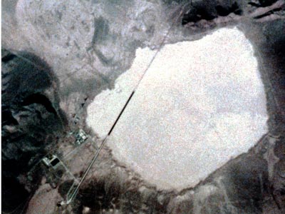
嫦娥ccd拍摄的照片和美国太空署照片的比较

中国首次月球探测工程第一幅月面图像是由嫦娥一号卫星上的CCD立体相机获得的。CCD相机采用线阵推扫的方式获取图像,轨道高度约200km,每一轨的月面幅宽60km,像元分辨率120m。中国第一幅月面图像共由19轨图像制作而成,位于月表东经83度到东经57度,南纬70度到南纬54度,图幅宽约280km,长约460km。图中右侧60公里宽的条带,是CCD相机开机获得的第一轨图像。
---------------------------------------------------------------------------------------------------
| 中國據報有網友質疑月球照片專家嚴辭駁斥 | | 中央社╱中央社 2007-11-30 11:21 |
http://news.yam.com/cna/computer/200711/20071130003724.html
(中央社記者林於國香港三十日電)中國嫦娥一號衛星傳回的首張月球照片公布後,據報導,有網友認為照片與google公布的月球照有驚人相同處,質疑嫦娥一號的月球照片與陝西的華南虎照片一樣都是假的。不過,嫦娥一號登月總指揮葉培建說,有關造假言論極不負責。
據香港「東方日報」報導,葉培建在做客中國航天網時說,「最近在網上看到個別網友很不負責任的說法,他們懷疑嫦娥一號的月球成像照片和華南虎照片一樣是假的。」
他說,「網絡(網路)是個非常自由的平台,但是也不能不負責任亂說。我們這麼多科學家都坐在這,而且溫家寶總理親自揭幕月球圖片,怎麼能是假的呢?」
據報導,嫦娥一號發回的第一張月球探測照片公布後,就有中國網友在人民網的「強國論壇」表示,嫦娥月圖與一款在google網站見到的月球照片幾乎相同,將嫦娥照片旋轉二十度以後,便與google的月球照片完全重合。
「嫦娥或許造假」文章在中國主要論壇廣泛轉載,引起網友熱議。不過,有網友認為,質疑嫦娥造假「錯不在網友」,為甚麼這麼多人質疑嫦娥的照片呢?因為大家真的怕了,見過了太多的假新聞。
[ 本帖最后由 pfg1group 于 30-11-2007 02:07 PM 编辑 ] |
|
|
|
|
|
|
|
|
|
|
|
楼主 |
发表于 30-11-2007 01:56 PM
|
显示全部楼层
阿波罗的秘密
http://www.thespacereview.com/article/1010/1
本篇文章根据解密资料,探讨冷战时期美国宇航署的角色。
由于先进的照相技术,美国太空署曾经计划在阿波罗上在中国大陆和前苏联上空拍摄照片。
由于拍照工作将会和其他情报机构的工作重叠,
这种做法让其他情报机关,尤其是国家情报办公室感到不安。
当时美国的照相技术已经相当先进,而且还具有相当的意义。
但是有些照片迟至1980年才公开。
而且,美国太空署绕过正常手段获取其他情报机构的意见也导致情报界对美国太空署的不满。
1974年,太空人甚至还拍摄了第51区的照片,虽然是否应该要发放公众激烈讨论,还是被公开了。
美国太空署是否被允许拍摄中国大陆和前苏联境内的情况至今还是机密。
而太空署和其他情报机构之间的问题也是在机密中。
by Dwayne A. Day
Monday, November 26, 2007
In May 1960 Francis Gary Powers fell out of a cold Siberian sky and into the flames of an international incident. But before the Soviet Union revealed that Powers was still alive, NASA implemented a cover story, rolling out a U-2 spyplane painted in agency markings and claiming that the missing airplane was a NASA aircraft on a civilian research mission. When the truth was finally made public, NASA was embarrassed and senior agency officials were outraged because they believed that they had been mislead by the intelligence community.
When a new NASA administrator took over in early 1961, NASA’s relationship with the intelligence community apparently improved significantly. But NASA’s mission of publicly proclaiming American technological capabilities and putting spacecraft and astronauts into Earth orbit created natural tensions with the agencies tasked with collecting information on America’s adversaries and obsessed with secrecy. Several incidents revealed in newly declassified documents from the Apollo era illustrate these tensions.
The Apollo program was carried out amid the klieg lights of the press on the world stage. That was, after all, the point—it had to be public, even the failures. However, there were aspects of Apollo that were classified. Relatively minor aspects, admittedly, but ones that still affected American national security.
There were aspects of Apollo that were classified. Relatively minor aspects, admittedly, but ones that still affected American national security.
In the event that an Apollo spacecraft was unable to leave Earth orbit, which could have happened if there had been a problem firing the third stage engine on the Saturn 5 which placed the Command and Service Modules and the Lunar Module on a lunar trajectory, or an early problem with the Lunar Module, the Apollo astronauts had a backup mission. They were supposed to circle the Earth and take photographs of the surface using the various cameras that they had aboard their spacecraft. Although this would have been a scientifically disappointing mission, and a major propaganda failure, it was NASA’s best attempt at salvaging something from the mission. For some of the later Apollo missions, the Command Module mounted a powerful camera intended for photographing the surface of the Moon. In Earth orbit, this would have produced relatively good photographs of the ground, better than any publicly released before—in fact, of a quality not publicly released until the 1980s.
Whenever the missions of government bureaucracies overlap government officials seek to coordinate their activities. This is to ensure that one agency does not do something that contradicts the policies of another agency, possibly causing embarrassment for the leadership and confusion for the public. In the case of NASA astronauts taking photographs of the Earth from space, this overlapped the jurisdiction of the US intelligence community, specifically the National Reconnaissance Office (or NRO), which was responsible for operating reconnaissance satellites for intelligence purposes. All American manned space missions starting with Gemini were coordinated with the intelligence community and astronaut photographs of the Earth were first reviewed by intelligence analysts before they were made public. In fact, in 1968 on the unmanned Apollo 6 mission, NASA planned on carrying an engineering camera to determine the orientation of the spacecraft in orbit, and sought intelligence community approval of this plan because the camera would take pictures of portions of the Earth at higher resolution than previously released.
In 1972, as NASA prepared for the last Apollo mission to the Moon, the agency sought to coordinate its plans for a contingency mission with the intelligence community, and created a bit of a stir in the process. The Apollo 17 spacecraft was carrying the Apollo Panoramic Camera, which had also been carried aboard Apollos 15 and 16. Previous photographs taken by astronauts with handheld cameras could not show much detail, but the new camera was much more powerful. More importantly, unlike previous missions, because of its unique trajectory, Apollo 17 could possibly overfly China and the Soviet Union, and the astronauts could return politically sensitive photography. NASA wanted the astronauts to take photographs of these areas.
The intelligence community was naturally sensitive to this issue. They were involved in a rather strange game of denying the obvious. Although it was widely known that the United States launched reconnaissance satellites, the official US government position was to not comment on the subject at all in order to not create any more questions, or international controversy, about the subject. In fact, the US government had even invented a euphemism—“national technical means”—in order to avoid referring to satellite reconnaissance in arms control negotiations. Photographs taken by American astronauts of the Soviet Union and China, some taken at relatively good resolution, could prompt awkward questions about American policies and capabilities. This was amplified by the particular capabilities of the Apollo Panoramic Camera.
Although it was widely known that the United States launched reconnaissance satellites, the official US government position was to not comment on the subject at all in order to not create any more questions, or international controversy, about the subject.
The Apollo Panoramic Camera was a derivative of an aerial reconnaissance camera known as the IRIS II, which was itself a derivative of the KA-80 camera. The KA-80 was originally designed for use on the SR-71 spyplane and later the U-2. It was what was described as an optical bar design, which enabled it to photograph a long thin image on a long strip of film at high resolution, and yet still remain compact enough to fit within the camera bay of an airplane or a spacecraft. It had a 61-centimeter focal length and from a 425-kilometer orbit could produce ground resolution of between 7.6 to 10.7 meters, meaning that a photographic interpreter could spot and identify large objects like buildings and some ships. At the time, American reconnaissance satellites fell into two general categories: “search” systems with resolution of about 2–3 meters and “spotting” systems with resolution as good as 15 centimeters. But the Apollo camera would have returned pictures far better than any ever made public before.
 |
|
|
|
|
|
|
|
|
|
|
|
楼主 |
发表于 30-11-2007 01:56 PM
|
显示全部楼层
阿波罗的秘密II
In October and November 1972, NASA contacted the National Reconnaissance Office and sought permission to take photographs of China and the Soviet Union using the Panoramic Camera and other cameras during an Apollo 17 contingency mission. A letter by Major Harold S. Coyle Jr. to the Director of the National Reconnaissance Office John McLucas from November 9 indicates that the NRO had reservations about NASA’s proposal. According to Coyle, the Office of the Secretary of Defense also was concerned about the proposal and recommended that NASA take a “more conservative approach”—i.e. not take any photographs of the Soviet Union or China during an Apollo contingency mission. NASA also approached both the State Department and the Arms Control and Disarmament Agency for their comment. The latter agency was concerned that NASA’s plan could impact the Strategic Arms Limitation Talks—NASA was, after all, proposing something that would prompt questions about “national technical means.”
In addition to proposing something that made intelligence agency officials nervous, NASA also apparently ruffled some feathers by not following the proper procedures and submitting its plan to each agency separately rather than via a coordinating committee that had been created for just such requests. In fact, by this time NASA apparently had a reputation for “going out of channels” for such requests, which annoyed those in the intelligence community.
In response to the various concerns expressed by several agencies, NASA redrafted its proposal, but still sought to take images of so-called “denied areas.” They then took their revised proposal to a special committee involved in approving all overhead photography plans. Unfortunately, those records have not yet been publicly released, so it is unclear if NASA obtained final approval of its plans to photograph parts of China and the Soviet Union if Apollo 17 was unable to go to the Moon.
Of course, Apollo 17 did go to the Moon, meaning that the debate was essentially moot—except for any hard feelings it may have left among those in the intelligence community who believed that NASA occasionally acted against their interests.
This was not the first time that NASA had annoyed the intelligence community with its astronaut photography, and it certainly would not be the last. In 1974, astronauts aboard the Skylab 4 mission had photographed the top secret airfield at Groom Lake in Nevada. Groom Lake, often euphemistically referred to as “Area 51”, is the site of classified aircraft research and is where both the U-2 and SR-71 spyplanes were first flown. Despite apparently explicit orders not to do so, the astronauts had taken a photograph of the airfield. This prompted a debate within the government after the film was returned to Earth. NASA wanted the photograph released in keeping with its mission of being open and public about its activities. Members of the intelligence community wanted the photograph classified because it depicted a secret facility. Other members of the government questioned the precedent of classifying previously unclassified material. (See “Astronauts and Area 51: the Skylab Incident”, The Space Review, January 9, 2006).
What these various incidents highlight is that the relationship between NASA and the intelligence community was not always a smooth one.
In my previous article on this subject I stated that the photograph in question had not been publicly released. This was untrue, and the result of sloppy research on my part (I assumed that because numerous Area 51 buffs had not previously located the photograph, it was not in publicly accessible archives—I broke one of my own research rules and never bothered to search myself. Then again, nobody’s perfect, and this isn’t the first time that the Internet has perpetuated an untruth…) It turns out that the photograph was placed in NASA’s archive of Skylab photographs. But nobody had noticed. So NASA won its argument with the intelligence community over the photograph. The photograph is published above.
What these various incidents highlight is that the relationship between NASA and the intelligence community was not always a smooth one. They could coordinate their activities if necessary, but they did not always agree—NASA espoused openness and peaceful use of space, whereas the intelligence community believed that national security required carefully guarding the capabilities of American cameras and other intelligence collection systems. And although these episodes illustrate examples where members of the intelligence community were unhappy with NASA, the civilian space agency had been burned by that intelligence community in a very public way back in 1960. How long any ill feelings remained at NASA over the U-2 incident is still unknown—but perhaps can someday be answered. |
|
|
|
|
|
|
|
|
|
|
|
楼主 |
发表于 30-11-2007 02:04 PM
|
显示全部楼层
爭雄太空 亞洲各國急起直追
http://news.yam.com/chinatimes/i ... 20071126982870.html
爭雄太空 亞洲各國急起直追
中時電子報╱楊明暐/綜合報導 2007-11-26 03:34
在中國「西昌衛星發射中心」,人們可以同時見識到中國發展太空科技的雄心、神秘兮兮的軍事文化及貧窮落後的農民生活。儘管眼前的一切在網路上都能找到,且中國的太空科技仍落後其西方對手,但外國人走近這座太空基地,仍免不了被解放軍擋下。
就在不遠處,一名農夫正驅趕著兩條水牛前進,他每個月的收入可能還不到人民幣80元(約台幣350元)。當地一位司機楊吉祥說:「雖然我們仍有許多窮人,我認為中國仍應增加在太空的投資,這顯示我國正繁榮壯大。我深信有朝一日我們會趕上美國。」
日、中先後探月 印度緊追
中國的太空科技發展備受外界關注,華府對中國的一舉一動自然很緊張,其鄰國也不甘示弱,紛紛推展自己的太空計畫。
10月24日,中國第一枚探月人造衛星「嫦娥一號」發射升空。在此之前,日本首枚探月衛星「輝夜號」已搶先一步於9月14日自種子島太空中心升空。而對中國一向戒慎恐懼的印度,準備在明年初發射其探月衛星。
在其它相關領域,印度於今年4月成功試射一枚能將核彈頭投射到亞洲大部分地區的彈道飛彈。今年2月,日本建構完成了一套由4枚偵察衛星組成的全球監視網路。
南韓也升高其對太空的野心,包括計畫將泡菜送上太空,就連馬來西亞也在研究其穆斯林太空人於每90分鐘即見到一次日出的太空中該如何遵守伊斯蘭教規,每天5次面向麥加祈禱。
商機、民族自尊 背後動力
對這些國家來說,發展太空科技可能著眼於其中潛在的商機,但背後的動力也包括它們日益增強的財富和民族自尊,特別是中國和印度,認為太空計畫是彰顯自身成就的一種方式。
美國太空科技專家喬納坦.麥克唐納說,他不確定西方在太空方面的領先地位是否正在跌落,不過很明顯的是,亞洲正在急起直追。
中國在太空領域日漸加快的腳步,正凸顯它自1970年以來所取得的長足進步。當年,科學家還警告在中國第一枚「東方紅」人造衛星上掛太多毛主席徽章,會妨礙衛星繞地球運行。
4年前,中國成功將太空人送上太空,成為繼美國和前蘇聯之後第三個掌握載人太空技術的國家。
為了恪遵「和平崛起」的原則,中國保持低調,不顯露任何挑釁意圖。北大地球與空間科學學院教授焦維新說:「未來,我們與美國的合作將多於競爭。」
然而,歐美國家仍對中國感到擔憂,尤其今年元月,中國成功發射飛彈,摧毀一顆老舊的氣象衛星一事,它們除了抱怨此舉製造了大量的太空垃圾,並指中國迄今仍是個不透明的社會。
咸認中一意孤行 歐美憂心
中國則反擊道,美、俄兩國多年來已進行過多次類似實驗,而太空垃圾一直是全球性問題,再者,任何國家對軍事機密都守口如瓶,不獨中國如此。
相較於中國,日本在深太空研究、機械人技術方面超前中國,並以更專精、更高科技的方式發展太空科技。然而日本預算有限,且缺乏民意支持,又幾乎得不到軍方奧援。
過去日本經歷發射失敗,總會在國內引發冷嘲熱諷,民眾對太空計畫的支持也隨之下降。目前日本雖已具備較可靠的發射系統,但太空領域必須與其它產業爭奪有限的工程人才。
印度在地球科技和工程技術方面擁有堅實的基礎,但它和日本一樣,面臨預算吃緊問題。新德里「和平與衝突研究所」所長班納傑說:「中國的資源超過我們10倍,和中國人比起來,我們還有一段很長的路要走。」
----------------------------------------------------------------
鉅資登天 南韓欲躋身前10大
http://news.yam.com/chinatimes/i ... 20071126982869.html
鉅資登天 南韓欲躋身前10大
中時電子報╱鍾玉玨/綜合報導 2007-11-26 03:34
亞太經濟大國爭雄太空。日本、中國相繼成功發射「輝夜號」、「嫦娥一號」等環月探測人造衛星之後,南韓也緊鑼密鼓進行太空計畫。
南韓的目標是擠入世界10大太空強國。根據該國擬定的「太空發展三步圖」,依序是發展衛星技術、掌握運載火箭技術、以及建造太空發射基地。而目前南韓已成功踏穩第一步,獨立研發的多功能人造衛星「阿里郎2號」去年成功升空運作。不過阿里郎2號仍然仰賴的是外國運載火箭與發射技術。
接下來南韓計畫在2017年之前,斥資39億美元獨自開發300公噸的運載火箭KSLV-II。至於另一型約170公噸的KSLV-1火箭係和俄羅斯技術合作,計畫在明年底之前發射升空,屆時南韓將成為世界上第9個能發射太空火箭的國家。
太空計畫的第三步是掌握發射技術。南韓計畫在2020年之前,將探月人造衛星送入月球軌道,接著是在2025年之前將探測船送上月球表面。
南韓也計畫每3、4年發射一枚重約100公斤的大型人造衛星,每年至少發射2枚小型衛星。
在太空發射基地方面,位於朝鮮半島南端外羅老島的太空中心預定明年啟用,發射台將可發射長33公尺、直徑3公尺的運載火箭,而南韓將成為全球第13個擁有火箭發射基地的國家,外羅老島太空中心則將成為全球第26個太空運載火箭發射場。
硬體之外,南韓也積極培訓太空人。南韓首位太空人預定在明年4月登上俄羅斯「聯合號」太空船而前往「國際太空站」,預計在太空站停留8天。
1992年以來,南韓即積極投入太空事業,希望拉近與中國、日本的差距,至今已投入1兆7千億韓元(約合台幣590億元)。不過綜觀世界太空大國的崛起之路,南韓能否如願實現太空雄心,仍是大問號。
------------------------------------------------------------------
探月後要上火星 印度展雄心
http://news.yam.com/chinatimes/i ... 20071126982868.html
印度日前宣布將在2008年初發射探月人造衛星,而且在第11個五年計畫中透露,有意在2105年左右發射無人探測器前往火星;印度的宣示,代表在新一波國際太空探測競賽中,新德里當局不願置身事外。
11月12日,印度航空暨太空研究組織主席奈爾與俄羅斯航太總署長佩爾米諾夫在莫斯科簽署兩國月球探險合作計畫,將進行到2017年底為止。
俄國研製無人航太工具主要機構「拉瓦奇金」公司總經理波利修克表示,俄國目前探月計畫分四個階段,第一步是2010年發射繞月衛星,第二步是2011年把新一代無人駕駛月球探測車送上月球表面。
波利修克表示,第二步將由俄、印兩國合作。印度負責由地表發射的運載火箭,還有從地球軌道到月球的太空推進器;俄方則提供登月著陸器、探測車以及各種科學研究儀器。本合作階段中,登月探測車重量大約400公斤,將由印度境內的發射基地升空。
印度選擇與俄國合作,目的在加快己方的探月進程。印度自己的登月計畫分三個階段,先是2008年發射小型探月衛星,接下來在2011到2012年間發射登月機器人,最後在2020年派遣印度太空人登陸月球。
印度第一階段探月計畫已開始裝置設備,繞月衛星將攜帶配有紅外線及X射線頻率的高精密遙測裝置。衛星將在離月表100公里的高度運行2年,勘察月球表面,繪製完整的月球成分地圖及三維地理圖。
第二階段便是與俄國合作。印度的主要任務除發射以外,還與俄方合作研製登月探測車;該機器人車登陸月表以後,將進行漫遊。據印度航空暨太空組織表示,第三階段最早將在2020年派印度太空人登陸月球。
但是,印度的雄心不止於月球,還放眼火星。「艾哈邁達巴德物理研究實驗室」主任戈斯瓦米表示,印度目前的火星計畫只是派遣太空船繞行火星軌道。
《印度時報》則報導,如果得到政府支持,印度可能在2015年左右,利用地球同步衛星載運火箭(GSLV)發射首個火星探測器;該探測器重約500公斤,配備功能強大的高解析度遠距傳輸裝置,不僅能收集火星大氣層的數據,分析其化學成分,還可以觀測火星表面及地下結構,尋找火星上的生命痕跡。
據印度初步規畫,2015年的火星探測過程為期5至8個月,斥資30億盧比(約6700萬美元)。
分析家表示,印度推動探月計畫同時匆匆公布火星探測計畫,應該與美、俄、歐洲等大國火星探測熱持續升溫有關。美國計畫今年起陸續發射「鳳凰號」及「火星科學實驗室」等火星表面探測車;歐洲航太總署決定,2011年重啟探測火星生命奧秘的火星登陸計畫。
俄國則計畫2030年左右派太空人登陸火星;中國則與俄國合作,預計2009年借助俄國的無人太空船,把中方衛星送往火星。
凡此種種,都讓南亞大國的印度認為,自己不能太落伍。 |
|
|
|
|
|
|
|
|
|
|
|
楼主 |
发表于 30-11-2007 06:46 PM
|
显示全部楼层
日本月姬绕月卫星开始制造3维地球表面照片
http://www.moondaily.com/reports/KAGUYA_(SELENE)_Composes_3_D_Movies_With_Terrain_Camera_Images_999.htm
KAGUYA (SELENE) Composes 3-D Movies With Terrain Camera Images
by Staff Writers
Tokyo, Japan (SPX) Nov 30, 2007
The Japan Aerospace Exploration Agency (JAXA) successfully demonstrated production of stereo movies (3 dimensional movies) of the Moon surface by using stereoscopic images obtained with the Terrain Camera (TC) onboard KAGUYA on Nov. 3, 2007 (Japan Standard Time, JST). This verification was performed as part of the initial check out of mission instruments onboard "KAGUYA" (SELENE), which was injected into the Moon's orbit at an altitude of about 100 km.
These are the first 3-D movies of the Moon including its polar areas with an aerial resolution of 10 meters.
Terrain Camera (TC)
The Terrain Camera (TC) can observe the Moon surface during the day-time of the Moon using two cameras that respectively face the slightly diagonal fore looking and aft looking of the satellite. It can take three-dimensional (stereo) images of the Moon's globe with a world's first super high definition of 10 m.
Three-dimensional terrain images acquired by TC high resolution stereo pair cameras are important data to study the evolution process of the Moon's unique terrain. With detailed investigation of the crater distribution, we can estimate more precisely when each area of the Moon has been formed and can study more details of when the Moon was born and how its inside and surface have been changing. Furthermore, data acquired by the TC is expected to be useful for studying topographical characteristics and illumination map to determine the best location for a future Moon base and to consider manned activities on the Moon.
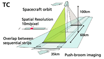
The Terrain Camera (TC) can observe the Moon surface during the day-time of the Moon using two cameras that respectively face the slightly diagonal fore looking and aft looking of the satellite. It can take three-dimensional (stereo) images of the Moon's globe with a world's first super high definition of 10 m.
在100公里高空,日本的平面ccd分辨率高达10公尺,为世界上第一架可以提供这么高精度的照相机。
相反的,在200公里高空,中国嫦娥的照片分辨率仅为120公尺。
----------------------------------------------------------------------------
其他有关电影:
- 3D image around DYSON crater by TC
http://space.jaxa.jp/movie/20071128_kaguya_movie01_e.html
- Anaglyph moving image around DYSON crater by TC
http://space.jaxa.jp/movie/20071128_kaguya_movie02_e.html
- 3D image near the South Pole by TC
http://space.jaxa.jp/movie/20071128_kaguya_movie03_e.html
[ 本帖最后由 pfg1group 于 30-11-2007 06:49 PM 编辑 ] |
|
|
|
|
|
|
|
|
|
|
|
楼主 |
发表于 1-12-2007 10:24 PM
|
显示全部楼层
欧洲:要警惕中国抢占卫星发射市场
http://news.bbc.co.uk/chinese/si ... 7122400/7122457.stm
欧洲卫星发射公司负责人提醒美国提防中国以低廉的价格抢占商业卫星发射市场。
今年5月,中国成功将一颗尼日利亚通讯卫星送入太空。
那是中国首次以整体方式为国际用户提供商业卫星服务,中国从而迈入商业卫星的国际市场。
欧洲卫星发射公司阿丽亚娜的总裁雷高乐周五(11月30日)在美国华盛顿向业界发表演说。
他指出,如今中国重新打入商业卫星发射市场,并且生产无须美国技术的卫星。
雷高乐表示:"中国企图借着低廉的发射价格全面渗透到这个市场,因此欧美应该联手对付这个非常非常严重的问题。"
他更加认为"每一个人"都因为中国的行为而吃苦。
价格优惠
不过观察人士认为,中国提供价格优惠的卫星发射服务,对于发展中国家来说具有相当的吸引力。
新华社早前报道,中国已经与委内瑞拉签订了卫星发射合同,预计明年下半年在中国发射升空。另外,还有多个国家已经表示出购买意向。
今年11月12日,由于在发射准备过程中再次出现技术故障,阿丽亚娜决定无限期推迟原定于当晚进行的一枚阿丽亚娜5型火箭的发射。
按计划,该次发射任务是运载巴西一枚民用通信卫星和英国的军事通信卫星。
中国曾于1990年在西昌卫星发射中心首次承揽外星发射,长征系列火箭从此迈入国际商业发射市场,但中国卫星从未出口。
中国媒体认为,5月成功将一颗尼日利亚通讯卫星送入太空,向世界证明了中国能够出口高水平大容量通信卫星,将会为中国航天带来更多的机会。 |
|
|
|
|
|
|
|
|
|
|
|
楼主 |
发表于 1-12-2007 11:44 PM
|
显示全部楼层
NASA六日發射亞特蘭提斯號太空梭
http://tw.news.yahoo.com/article/url/d/a/071201/1/p6vd.html
美國航空暨太空總署(NASA)宣佈,將在美東時間12月6號下午4點31分,也就是台北時間12月7號凌晨5點31分,發射「亞特蘭提斯」號太空梭,把歐洲的「哥倫布」實驗艙,送上國際太空站。
哥倫布實驗艙呈圓筒形,直徑約4.6公尺,長約7公尺,太空人將在裡面,進行無重力狀況下的生物與物理實驗。
---------------------------------------------------------------
美“阿特兰蒂斯”号航天飞机定于12月6日发射
http://news.xinhuanet.com/newsce ... content_7179341.htm
新华网华盛顿11月30日电(记者 张忠霞)美国宇航局30日宣布,“阿特兰蒂斯”号航天飞机 定于12月6日发射,这将是今年最后一次航天飞机飞行。
美宇航局说,“阿特兰蒂斯”号预定美国东部时间12月6日16时31分(北京时间12月7日5时31分)发射。这次飞行主要任务是将欧洲的“哥伦布”实验舱送上国际空间站。
美宇航局官员在为期两天的“阿特兰蒂斯”号飞行准备评估会议结束后,宣布了上述发射时间。“阿特兰蒂斯”号机组7名宇航员将于12月3日抵达美国佛罗里达州肯尼迪航天中心,进行发射前的最后准备。
美国今年共计划安排4次航天飞机飞行,现役3架航天飞机“阿特兰蒂斯”号、“奋进”号和“发现”号今年已分别执行了一次飞往国际空间站的任务。美宇航局希望在2010年航天飞机退役前完成国际空间站的建设任务。 |
|
|
|
|
|
|
|
|
|
|
|
楼主 |
发表于 1-12-2007 11:46 PM
|
显示全部楼层
执行嫦娥一号卫星海上测控任务的远望三号测量船回国
http://news.xinhuanet.com/newsce ... content_7181043.htm
新华网南京12月1日电(记者王玉山)执行完嫦娥一号卫星海上测控任务的远望三号测量船12月1日15时顺利抵达江南某码头。此前,远望二号测量船已于11月12日顺利抵港。至此,执行嫦娥一号卫星海上测控任务的两艘航天远洋测量船全部安全返回。
远望二号和远望三号测量船从今年10月初开始,共赴南太平洋某预定海域,联袂执行嫦娥一号卫星海上测控任务,历时近60天,总航程2万余海里,相当于绕地球赤道一圈。
中国卫星海上测控部主任饶顺和在接受新华社记者采访时表示,作为中国航天测控网的重要组成部分,远望号航天测量船在嫦娥一号任务中,圆满完成了火箭发射段的遥、外测任务,卫星发射段及入轨段的遥、外测任务,以及卫星三次近地点变轨段、调相轨道段、月球捕获轨道段、环月运行轨道段的跟踪测轨、遥测和遥控任务。
饶顺和说,嫦娥一号卫星海上测控任务的技术难度、复杂程度和工作强度都超过了以往任何一次。仅就远望三号测量船而言,这次任务的测控时间相当于这艘船以往历次任务测控时间总和的2倍多。同时,执行任务的南太平洋预定海域处于图瓦卢群岛、托克劳群岛和北库克群岛之间,岛礁多,没有国际推
荐航线,没有详细的航海资料,对设备可靠性和参试人员技术水平提出了很高要求。
今年适逢中国远望号航天测量船队组建29周年,饶顺和告诉记者,远望号航天测量船29年来已56次远征大洋,累计航行130多万海里,成功执行了65次重大试验任务,成功率为100%,其海上航天的测控能力、测控精度、自动化程度和可靠性等整体技术性能均达到国际先进水平。
根据计划安排,远望三号测量船明年将再度征战大洋200余天,执行包括神舟七号飞船在内的多项海上测控任务。 |
|
|
|
|
|
|
|
|
|
|
|
楼主 |
发表于 2-12-2007 12:13 AM
|
显示全部楼层
太空對保安企業科學價值定位講座
http://www.chinapress.com.my/con ... ;art=1202m55a20.txt
太空對保安企業科學價值定位講座
賽慕斯扎法:無緣見萬里長城
太空望見檳城好感動
(吉隆坡1日訊)大馬太空人賽慕斯扎法說,他在國際太空站上,曾望見檳城島嶼,令他感到深深感動。
他說,在未上太空前,曾聽人說中國萬里長城是在太空中,唯一能以肉眼看到的建築物,不過,他在國際太空站的10天內,卻無緣看見。
“我沒看到萬里長城,不過卻看到檳城島嶼,那景色實在太美了。”
賽慕斯扎法是今日出席主題為“太空對馬來西亞保安、企業及科學的價值定位”講座會上,發表上述談話。
他說,在國際太空站的首9天,他都忙著進行各項太空實研及任務,根本沒有時間欣賞外頭的景色,而且太空站經過中國上空時,大多數是在晚上時分,所以沒能看到萬里長城。
沒時間欣賞外景
他指出,在太空站時,他一直嘗試找出大馬的所在,不過,由于當時赤道上空太多雲霧,所以沒法看到完整的大馬國土,只看到小小的檳城島嶼。
針對出席者詢問他的終身大事時,賽慕斯扎法也坦言,現在的他的確有要安定下來的想法,並計劃在2009年結婚。
“我是一名外科整形醫生及餐館老板,也曾當過兼職模特儿,我喜觀多元化的生活,因我認為多元化的生活,能讓我挑戰自己的極限,看看自己能夠走多遠,但現在我想是時候安定下來了。”
他笑言,他已35歲了,也想安定下來,不過,結婚絕對不會影響他對工作的熱忱及造成阻礙。
~~~~~~~~~~~~~~~~~~~~~~~~~~~~~~~~~~~~~~~~~~~~~~~~~~~~~~~~~~~`
重返地球肩負使命
激發新生代科學興趣
http://www.chinapress.com.my/con ... ;art=1202m55a22.txt
(吉隆坡1日訊)大馬太空人賽慕斯扎法說,大馬落實太空人計劃,並不是浪費金錢,他的任務也不是到太空旅行。
他說,他肩負重大的國家使命及完成太空科學實研,重返地球后,他的工作就是要啟發國家新生代,激起他們對太空科學的興趣。
他說,羅馬之所以強大,是因征服大片土地,英國之所以強大,則因征服了海洋,如今,如果有人能征服太空,就成為世界的王者。
“我已完成身為大馬太空人的使命,我的升空已改變了人民的思維,提升了國人對太空科學的興趣,我也會繼續通過經驗分享,啟發年輕國人對太空的興趣。”
他認為,太空人計劃必須繼續擴大,政府也必須加強太空科學的研究與開發,吸引在太空領域學有所長的專才回國服務,使宇航領域取得更大發展。
=========================================================
太空實驗耗1500萬
宇航局:沒浪費金錢
http://www.chinapress.com.my/con ... ;art=1202m55a23.txt
(吉隆坡1日訊)國家宇航局總監拿督瑪茲蘭說,政府送大馬太空人到太空10天,只花費1500萬令吉的太空實研費用,並沒浪費人民的金錢。
她重申,太空人計劃是政府向俄羅斯購買蘇愷戰機的一項配套,因此,政府送首名太空人到國際太空站,不需支付任何升空費用給俄羅斯。
瑪茲蘭是今日在一項主題為“太空對馬來西亞保安、企業及科學的價值定位”講座會上,針對一名出席者詢及為何政府不選擇發射成本較低,設置太空望遠鏡的小型人造衛星,而要浪費大筆金錢及時間,送大馬人上太空一事,這么指出。
“太空人計劃是一項深具意義的計劃,政府會繼續發展宇航計劃,並訂下明確的發展目標。” |
|
|
|
|
|
|
|
|
|
|
|
楼主 |
发表于 2-12-2007 12:28 AM
|
显示全部楼层
錫慕查化:與美俄合作 大馬人或登月球火星
http://www.sinchew.com.my/conten ... ;artid=200712011219
(吉隆坡訊)大馬人可能在2017年以及2023分別登上月球和火星?大馬首名太空人錫慕查化表示,大馬政府繼續發展宇航業,與美國和俄羅斯合作上太空計劃,將有機會隨美國2017年登月以及俄羅斯登火星計劃,共創更上一層樓的太空夢想。
“如果有機會,我也想再上太空!太空經驗對我而言是一生中最難忘的回憶!”
他今天(週六,12月1日)在大馬科學學術機構所舉辦的講座會上回答聽眾的問題時說,他曾經涉及多個領域,也親身到不同國家去尋找他的靈魂,卻始終找不到答案,最後他在浩瀚太空中找到了他的答案,他的靈魂!
“我在回地球前3個小時,我聽到了上蒼的呼喚,我感覺到我需要以太空人身份,回到我的國家為人民服務,我有了一種有生以來最平靜的心靈感受。”
太空梭上看到檳城
詢及他是否在太空梭上看到長城時,錫慕查化說,他只有在最後一天才有空專心地往外看回地球,但他看不到任何建筑物,包括長城。
“但是,我看到檳城,非常美麗,我看過最美麗的檳城。”
他說,他對於從太空看回地球的感覺非常難忘,第一次看到的感覺更有美麗得令感覺心跳停止的震撼,令他無法忘懷!
科學實驗具重大意義
太空人計劃非浪費
錫慕查化也一再強調,太空人計劃不是浪費金錢、浪費時間的,因為他在太空上做的實驗對於大馬科學領域發展有重大意義,而且重要的是實現了大馬人升上太空的夢想。
“我相信每個人都有升上太空的夢想,而我實現了所有人的夢想,也希望回國改變國人的思想,往這夢想前進,未來成為太空人!”
他說,他升空也將大馬文化帶上太空,向全世界人民展現大馬文化,也激發了回教國家開拓太空計劃,想進行太空計劃的回教國家也向大馬請教如何在太空祈禱的方法;大馬因為太空人計劃而提升了國際地位!
“我很幸運地成為太空人,而我愿意一生以太空人的身分為國家為人民服務!”
宇航局:開拓宇航業
上太空目的將更明確
國家宇航局總監拿督瑪茲蘭認為,政府應該繼續開拓和發展宇航領域的可能性,繼續送大馬人民上太空,只是第二次太空人計劃目的應該將會更加明確。
她也認為,太空人計劃並沒有所謂浪費錢的問題,因為這次計劃是國防部向俄羅斯購入蘇凱戰機的配套計劃,所以並沒有奢侈花錢的問題存在;而這計劃的費用則是1400萬令吉的科學實驗費用以及她不知道數目的宣傳費。
她說,宇航局一向面對經費和設備不足的問題,而太空人計劃的成功促成第二次太空計劃有機會落實,而宇航局也在未來相信可獲得更多機會開拓宇航業。
計劃非用配套換取
“因此我們應該繼續進行太空人計劃,這次不是用配套換來的計劃,所以目的宗旨需要更加明確和精心策劃。”
她說,事實上開拓宇航業會帶來許多回報,像大馬這樣的小國通過了發展宇航業,可促進國際對話,提昇國家地位。
她指出,如中國近年來積極發展宇航業,發展出自己一套宇航系統,也增加了與強國,尤其是美國談判的籌碼。 (星洲日報•2007.12.01) |
|
|
|
|
|
|
|
|
|
|
|
楼主 |
发表于 2-12-2007 11:44 PM
|
显示全部楼层
美耗资数十亿美元 研发下一代谍报卫星
http://www.zaobao.com/gj/gj071202_501.html
(华盛顿美联电)美国正在进行一项几十亿美元的新计划,以研发下一代的谍报卫星。这是美国国防部自两年前取消波音公司的卫星计划以来,规模最大的一项研发卫星工程。
由于计划属机密,受访官员都要求匿名。他们说,预计在2011年前部署的新系统所需资金介于20亿美元(约29亿新元)到40亿美元。
谍报卫星,也就是所谓的影像侦察卫星,可以从空中搜集有关敌国或恐怖组织的最新活动资料。这类卫星也可以用来视察风灾、火灾等自然灾害所造成的破坏。
尽管国防部已经在进行新卫星计划,美国许多议员和国防专家对卫星计划的昂贵费用都提出质疑,尤其是当局在浪费了大量人力物力后,还是取消了上一个卫星计划。
国防专家和官方报告说,美国侦察办公室花了6年的时间和几十亿美元研发“未来影像建筑系统”,不过,却在2005年9月份取消有关计划中的一个主要项目。这是由于该项目的主要承包商波音公司在研制光电卫星时,遇到技术上的问题,因此严重超支30亿美元。国防部因此赶紧喊停。
这项新卫星计划正处于准备招标的最初阶段。国防部在今年秋季就新卫星科技向国防科技业发出招标预告通知书。国防部预料将在明年春季要求投标商交出计划书。
国防部正进行研究,以确定新卫星的功能。有关分析报告在年底前完成。 |
|
|
|
|
|
|
|
|
|
|
|
楼主 |
发表于 4-12-2007 03:21 AM
|
显示全部楼层
美軍GPS系統大升級 各國核試風吹草動盡收眼底
http://news.xinhuanet.com/world/2007-12/01/content_7178235.htm
法國媒體11月27日報道,為確保美國在全球定位系統領域的絕對領先地位,超越歐洲和中國聯手的“伽利略計劃”,美軍決定對GPS進行有史以來最大規模的升級。升級後的美軍第三代全球定位系統傳輸量是現行的500倍,而抗幹擾能力將翻番。軍事觀察家認為,此舉將引爆新一輪的GPS全面競爭,而這場競爭也關系到普通人的生活。
上周,歐盟議會正式拍板:向因資金不足而陷入困境的“伽利略計劃”注資24億歐元,以實現2013年“伽利略計劃”全面投入使用的目標。據有關官員透露,“伽利略計劃”提供的全球定位系統服務將以“更精確、更可靠”的優勢,超過美國現有的GPS。
“伽利略計劃”的這一最新舉措令美國大受刺激,美國空軍GPS聯隊司令戴維﹒邁登11月27日在接受法新社記者採訪時說:“美國正式決定啟動第三代GPS計劃,這將為我們的軍事和民間用戶提供更適時、更精確、更可靠、更能抗幹擾的定位和導航服務。”他說,“第三代GPS第一階段將於2013年年底前部署到位,而整個第三代GPS網絡最終由32顆新型衛星組成。一旦部署完成,其性能至少不亞於歐洲與中國合作的‘伽利略計劃’。”
傳輸量增500倍抗幹擾能力翻番
美軍第三代GPS究竟強在哪裡呢?
據美國全球安全組織一名國防分析家表示,美國的第三代GPS與現行的GPS系統相比,有3個特點:
首先是第三代GPS傳輸能力是現在GPS的500倍,而抗幹擾能力也較現在的GPS翻番,這意味著GPS的數據和音像傳輸速度大增,用戶享受的“適時服務”也更加完善,且GPS遭幹擾中斷的風險也將大減。
其次是第三代GPS的精確性將有極大提高。據美國軍方透露,第三代GPS將讓所有的用戶,比如說空中的飛行員和地面的駕駛員能夠精確定位地球上任何一個點,且精確度達1米,而此前美國GPS的精確度只有數米。
第三是為民間開放更大的使用空間,按美國五角大樓的設想,第三代GPS將新開放兩個民用頻段──1227.60 MHz和1176.45 MHz,好讓民間用戶更方便使用GPS。
能掌握全球核試的風吹草動
美國如此急切推出第三代GPS系統的目的,就是全面超越歐洲與中國合作研發的“伽利略計劃”,確保美國在GPS領域的絕對領先地位。
美國五角大樓的多名官員直言不諱地說,搶著部署第三代GPS的目的很明確,那就是完成布什總統制定的目標,即確保第三代GPS仍能成為“世界標準”。
布什總統要求第三代GPS既要與美國的聯邦無線導航計劃相容,也要與當今世界無線電導航系統兼容。此外,還要與美軍“核爆探測系統”相聯。借助先進的電子測量裝置,通過捕捉核爆炸激發的電磁脈沖、光脈沖、空氣沖擊波、次聲波和地震波等信息,可確定有關核爆炸參數,而與美軍的新型GPS系統相連,全球任何地域進行核試驗,都會立即被監控,其精確地點和爆炸參數會迅速傳到美軍決策層,從而能掌握全球核試的任何風吹草動。
美國從去年開始對“已顯老化”的GPS技術進行更新,改善了衛星信號,提高了抗幹擾能力,以及定位精度。但真正刺激美國急著拋出第三代GPS的是歐洲與中國合作的“伽利略計劃”。
“伽利略”計劃是一種中高度圓軌道衛星定位方案。“伽利略”衛星導航定位系統將於2007年底前完成,2008年投入使用,2013年全面運轉,總共發射30顆衛星,其中27顆衛星為工作衛星,3顆為候補衛星。
該系統將為歐盟成員國和中國的公路、鐵路、空中和海洋運輸甚至徒步旅行者,提供精度為1米的定位導航服務,從而將打破美國獨霸全球衛星導航系統的格局。
由於目前全世界使用的導航定位系統主要是美國的GPS系統,歐洲人認為這並不安全。為了建立歐洲自己控制的民用全球導航定位系統,歐洲人決定實施“伽利略”計劃,這也是世界上第一個基於民用的全球衛星導航定位系統。
2003年9月18日,歐盟和中國草簽了中國參與“伽利略”計劃的協議。2004年10月9日,雙方又簽署了此項目的技術合作協議。因而引發美國媒體發出美國可能擊毀“伽利略”衛星的報道。
可見,此項目不但具有極高經濟價值,也深具政治和軍事戰略意義。
正是由於“伽利略計劃”的軍事與民用戰略意義,美國才會如此急迫。據GPS首位制造商美國的洛﹒馬公司發言人史蒂夫﹒塔圖曼介紹,美國空軍會在2008年年初向美國軍工企業下達生產制造合同,而美國空軍也透露說,除了洛﹒馬公司外,還將地面基地和天線的合同分別交給諾﹒格公司和雷聲公司。 |
|
|
|
|
|
|
|
|
|
| |
 本周最热论坛帖子 本周最热论坛帖子
|


 1767
1767  43
43